Mt St Helens
Eruption Summary -
|
||
|---|---|---|
| VOLCANO | Elevation of Summit: | 9,677 feet before; 8,363 feet after; 1,314 feet removed |
| Volume removed (based on uncompacted deposits): | 0.67 cubic miles (3.7 billion cubic yards) | |
| Crater dimensions: | 1.2 miles (east-west); 1.8 miles (north-south); 2,084 feet deep | |
| Crater floor elevation: | 6,279 feet | |
| ERUPTION | Date: | May 18, 1980 |
| Time of initial blast: | 8:32 a.m. PDT | |
| Eruption trigger: | A magnitude 5.1 earthquake about 1 mile beneath the volcano | |
| LANDSLIDE - DEBRIS AVALANCHE |
Area and volume (volume based on uncompacted deposits): | 23 square miles (0.67 cubic miles) (3.7 billion cubic yards) |
| Depth of deposit: | Buried North Fork Toutle River to average depth of 150 feet (maximum depth 600 feet) | |
| Velocity: | 70 to 150 miles per hour | |
| LATERAL BLAST |
Area covered: | 230 square miles; reached 17 miles northwest of the crater |
| Volume of deposit (based on uncompacted deposits): | 0.046 cubic miles (250 million cubic yards) | |
| Depth of deposit: | From about 3 feet at volcano to less than 1 inch at blast edge | |
| Velocity: | At least 300 miles per hour | |
| Temperature: | As high as 660 degrees F (350 degrees C) | |
| Energy release: | 24 megatons thermal energy (7 by blast, rest through release of heat) | |
| Trees blown down: | 4 billion board feet of timber (enough to build about 300,000 two-bedroom homes) | |
| Human fatalities: | 57 | |
| LAHARS | Velocity: | About 10 to 25 miles per hour (over 50 miles per hour on steep flanks of volcano) |
| Damaged: | 27 bridges, nearly 200 homes. Blast and lahars destroyed more than 185 miles of highways and roads and 15 miles of railways. | |
| Effects on Cowlitz River: | Reduced carrying capacity at flood stage at Castle Rock from 76,000 cfs (cubic feet per second) to less than 15,000 cfs | |
| Effects on Columbia River: | Reduced channel depth from 40 to 14 feet; stranded 31 ships in upstream ports | |
| ERUPTION COLUMN AND CLOUD |
Height: | Reached about 80,000 feet in less than 15 minutes |
| Downwind extent: | Spread across U.S. in 3 days; circled Earth in 15 days | |
| Volume of ash (based on uncompacted deposits): | 0.26 cubic miles (1.4 billion cubic yards) | |
| Ash fall area: | Detectable amounts of ash covered 22,000 square miles | |
| Ash fall depth: | 10 inches at 10 miles downwind (ash and pumice); 1 inch at 60 miles downwind; 1/2 inch at 300 miles downwind | |
| PYROCLASTIC FLOWS |
Area covered: | 6 square miles; reached as far as 5 miles north of crater |
| Volume and depth (volume based on uncompacted deposits): | 0.029 cubic miles (155 million cubic yards); multiple flows 3 to 30 feet thick; cumulative depth of deposits reached 120 feet in places | |
| Velocity: | Estimated at 50 to 80 miles per hour | |
| Temperature: | At least 1,300 degrees F (700 degrees C) | |
| OTHER | Wildlife: | The Washington State Department of Game estimated nearly 7,000 big game animals (deer, elk, and bear) perished as well as all birds and most small mammals. Many burrowing rodents, frogs, salamanders, and crawfish, managed to survive because they were below ground level or water surface when the disaster struck. |
| Fisheries: | The Washington Department of Fisheries estimated that 12 million Chinook and Coho salmon fingerlings were killed when hatcheries were destroyed. Another estimated 40,000 young salmon were lost when forced to swim through turbine blades of hydroelectric generators as reservoir levels along the Lewis River were kept low to accommodate possible mudflows and flooding. | |
May 18, 1980 dawned clear and bright. It was an amazingly beautiful day for May in the Pacific Northwest. Being a Sunday, there were only a few loggers, campers and scientists in the area. Many of these people had been lulled into a false sense of security because of the mountain's recent silence. Not even the scientists could predict exactly what was to come.
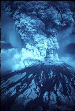
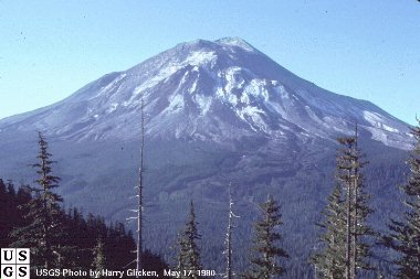
Both of the pictures below were taken from Johnston Ridge, just 5 miles northwest of the summit. It was here that U.S. Geological Survey vulcanologist, David Johnston, was taking measurements the morning of the 18th. At 8:32 a.m. (PST), Johnston radioed "Vancouver! Vancouver! This is it!", only moments before he was struck by the advancing wall of rock, ice and trees that swept laterally from the mountain at more than 500 miles per hour. His body has never been found. In May of 1997 an observation and education center was built on Johnston Ridge in his honor. It is the visitor's center closest to the mountain. (photos below by Harry Glicken, USGS)
At 8:32 a.m. a 5.1 magnitude quake struck one mile below the mountain. While there had been literally hundreds of earthquakes at the mountain since March 20th, the unstable north face could not sustain another. Within moments the largest landslide in recorded history removed more than 1,300 feet from the summit and swept away almost the entire north side of the mountain. The elevation of the mountain dropped from 9,677 feet to its present day 8,363 feet. What was once the 9th highest peak in Washington state was suddenly reduced to the 30th highest peak. The intense high pressure/high temperature steam that escaped, instantly turned more than 70% of the snow and glacial ice on the mountain to water. This massive movement of rock, ash, water and downed trees swept into Spirit Lake and down the north fork of the Toutle River Valley at speeds in excess of 175 miles per hour.
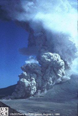
As the north face slid away it let loose the trapped gases like a cork removed from a well shaken bottle of champagne. The three pictures below are from a series of photos taken by Gary Rosenquist who was camping at Bear Meadows, 11 miles north east of the mountain. Rosenquist and the rest of his party survived the eruption even though the lateral bast was rushing straight in their direction at speeds nearing 650 miles per hour. Luckily, after rolling over ridge after ridge, the blast suddenly turned. In the last picture you can see the lateral blast overtaking the landslide. In only three minutes the blast flattened 230 square miles of old growth forest in a fan shape north of the mountain.
Mt. St. Helens is on an ocean-continent subduction boundary (the Juan de Fuca plate is subducting under the N. American plate). Mt. St. Helens is an active strato volcano. The easiest answer to what caused the eruption is that a body of magma moved into the shallow part of the volcano between the first earthquakes and minor eruptions in March, and by May 18th had become so pressurized that the north face of the mountain failed and this magma was able to erupt.
The slow moving collision of the continental rock of North America and the Oceanic Rock of the Juan de Fuca tectonic plate, which is slowly moving beneath the Pacific Northwest is slowly refueling Mount St. Helens for another eruption. Scientists estimate that there is a large reservoir of magma four miles beneath the crater. No one knows enough about the volcano to predict when it will erupt again or what kind of volcanic activity the next eruption might bring.
The eruptions effects were far reaching . . .
| As the north face of the mountain collapsed, expanding
gases and steam from the molten rock hurtled rock and ash out across the
land at speeds up to 670 miles per hour uprooting trees as far as 6 miles
from the mountain. It was impossible to outrun and the searing heat too
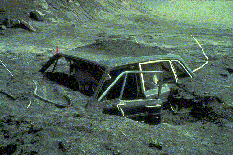
intense. Reid Blackburn, a photographer with The Columbian newspaper
was one of the first victims of the eruption. Blackburn had tried to take
shelter in his car but the lateral blast blew in the windows, letting in the
hot, choking ash. He was found in his car 7 miles north of the mountain.
(photo by Daniel Dzurisim)
For more information regarding the 57 people who were killed, please see my Eruption Victims page. |
|
|
|
Along with the loss of human life, it seemed the plants
and animals in the area were almost completely wiped out as well. It is
estimated that 5,000 black-tailed deer, 1,500 Roosevelt elk, 200 black
bears, and 15 mountain goats fell victim. Millions of small game, fish,
birds and insects were also in the path of the eruption.
The areas nearest the mountain were completely stripped of topsoil by the lateral blast. Nothing remains but bare rock. For weeks after the eruption, pyroclastic flows (seen here at left) of escaping steam and ash rolled down the remains of the north face, sterilizing the soil with its intense 1200 degree heat and depositing pumice and ash up to 60 feet thick in the valley below. Two weeks after the eruption when temperature measurements could safely be made, the pyroclastic deposits still averaged 650 degrees. Today, the pumice plan, a fan shaped area just below the crater, has been heavily eroded by wind and rain. |
| Directly in the path of the huge landslide was Spirit Lake. Normally a chilly 42 degrees, the landslide instantly raised the temperature to near 100 degrees. As the mud and rock hit the lake, the intense temperatures and choking ash killed all of the life in the water. Like dropping a large rock into a bucket of water, the lake sloshed up onto the surrounding hillsides, pulling trees and other debris into the lake. With the addition of heavy metals from the mountain and all the organic material washed down from the hillsides, huge bubbles of methane gas escaped from the lake for months after the eruption. Today the bottom of Spirit Lake is 100 feet above the original surface. The lake now has two and a half times more surface area than it did before the eruption. This photo was taken from the top of Mt. St. Helens looking north. Mt. Rainier can be seen in the distance. (photo to right by Lyn Topinka, USGS) The water in the lake looks strange because there is a gigantic mat of logs floating on the surface. Today many of these logs have sunk or washed up on shore. Plants and small animals are slowly returning to the water but so far the water is still not able to sustain larger life such as fish. |
|
|
The larger portion of the landslide flowed down the Toutle River Valley at speeds of 30 miles an hour at times carrying rock (some boulders were as big as 20 feet in diameter), ash, trees and even homes downstream with it. Twenty-seven bridges were destroyed by the 25 foot tall wall of debris. By the evening of the 18th, the Army Corps of Engineers was forced to close the Columbia River at Longview, more than 75 miles from the mountain. The normally 40-foot deep channel had been reduced to 17 feet by ash sediment washed downstream. Even after six days of dredging, large freight ships could only navigate that section of the river during high tide "windows" when the channel was 30 feet deep. Even now the remains of the debris avalanche sends enough sediment down the river that it is a muddy brown and towns and cities downstream can flood if the sediment retention dam can not retain enough of the silt. |
The people around the mountain began their clean-up efforts almost immediately. To the amazement of scientists studying the effects of the eruption, Mt. St. Helens began cleaning up as well.